
Broward County Neighbor Records
Public records describe a Broward County block in layers. The parcel map establishes which lots surround the starting address. Property records link those folios to owners. GIS shows the municipality, ZIP, districts, waterways, and annexation context. A requested voter file may identify registered voters by residence address, with protected rows suppressed. Civic groups add public contacts and meetings, not a roster of every person nearby.
| Source | What It Shows About a Block | Access |
|---|---|---|
| BCPA parcel map | Parcel boundaries, folios, and owner links | Free click and browse |
| BCPA property roll | Owner, situs, tax mailing address, exemptions, and sales | Free record search |
| Broward County GIS | Municipal, ZIP, district, annexation, street, and flood context | Free layers and downloads |
| Registered-voter file | Registered voters by residence address, subject to suppression | Paid public-record request |
| Municipal civic pages | Association boundaries, officers, public contacts, and meetings | City or association page |
| Official Records plats | Subdivision lots, blocks, and easements | Free online search |
An owner name is not proof of occupancy. A unit may be rented, seasonal, held by a trust, or owned by a company. A tax mailing address may point outside Broward County or to a manager. Likewise, a voter entry proves registration at the recorded residence on the extract date, not that every household member appears or that the person is physically present now.
Click Broward County Neighbor Parcels
The BCPA Map offers the most precise starting point. Locate the known address, select its polygon, and preserve the folio. Click each polygon sharing an edge, then inspect parcels opposite the road and those touching a corner. Pan and zoom before deciding what counts as the block. Aerial imagery helps reveal canals, walls, parking areas, and private drives that break an apparent connection.
- Search the known address and select the exact parcel polygon.
- Open the linked property record and record its folio, situs, owner, and mailing address.
- Click every shared-edge parcel, then check the opposite side and corner geometry.
- For a condominium, switch to address results and review individual unit folios instead of counting one master footprint.
- Add municipality and district layers before choosing a custodian or civic group.
This method is narrower than tracing an entire road. When the question expands beyond the immediate block, use the Broward County street directory workflow instead of extending guesses from one map view.
Note: Sequential house numbers can skip, cross a canal, or turn a corner, so geometry is safer than number order.
Broward County Neighbor Geography
Broward County geography often complicates the word “neighbor.” A condo tower can place many separate folios at one street number. Common elements may belong to an association rather than a person. Waterfront parcels can appear close across a canal but have no road link or shared civic group. Corner lots may use the cross street as their situs. Vacant drainage tracts and road parcels may interrupt the sequence.
Gated and private streets add another mismatch between a mailing label and a legal description. Port Everglades and airport lands also cross common postal assumptions. Inspect the parcel boundaries, aerial image, and right-of-way before grouping addresses. For a tower, enumerate unit records by the shared address. For detached homes, record which edge or road relationship makes each parcel part of the chosen block.
Map Broward County Neighbors
After the geometry is set, open each parcel record. Compare situs and tax mailing addresses, note the owner name, and preserve the folio. A homestead exemption can be a clue about owner occupancy, but it is not a list of all people in the home. A different mailing address may point to a seasonal owner, trust, business, or management arrangement. Label it as tax correspondence unless another source supports more.
Then open Broward County GIS and Maps. Add municipality, ZIP, annexation, district, address-point, street-centerline, or flood layers as needed. A Fort Lauderdale postal label can refer to another municipality or an unincorporated area, so the map determines which clerk, permit office, or civic list fits the parcel.
Use a compact record flow for each lot: address → parcel polygon → folio → property record → owner and mailing address → municipality and district. Repeat it consistently. This keeps the block from becoming a loose list of nearby names and makes each result traceable to a public record.
Broward County Neighbors in Voter Data
The individualized Broward voter lookup requires a first name, last name, and date of birth. It is not a public browse-the-block tool. Street-level work uses the registered-voter report available from the Broward Supervisor of Elections data-request process. The request can specify voter geography, selection, format, and delivery. Published pricing states a $20 voter-list search, a $6 optional USB, and Dropbox delivery for files over 10MB.
A voter file may contain name, residence and mailing addresses, party, status, registration date, precinct and district codes, and participation flags. Participation says only whether a ballot was cast, never how anyone voted. Active, inactive, and cancelled are administrative labels. Preserve the extract date because list maintenance changes them.
Florida law removes Social Security, driver-license, and state-ID numbers. It also protects registration-location data, preregistered minors, and copying of signatures. Protected-address records remain suppressed. The Florida voter confidentiality statute is visible in this assigned capture.
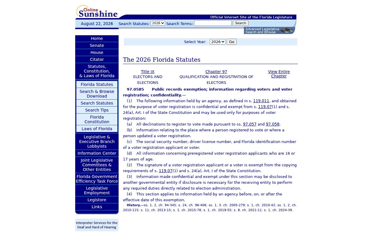
The statutory page reinforces a key block rule: an absent row must stay absent and should never be reconstructed from sequence gaps or another database.
Broward County Neighborhood Contacts
Neighborhood organizations are community contacts, not government resident directories. Broward County has no authoritative countywide list of every homeowner, condominium, and civic association. Check the municipality after mapping the parcel. Public pages commonly show an association boundary, officers, contact method, meetings, or events. They usually do not publish a membership roster.
Fort Lauderdale Civic Associations
The Council of Fort Lauderdale Civic Associations and city-recognized groups can help identify public meetings and neighborhood boundaries.
Hollywood Civic Associations
The Hollywood Council of Civic Associations provides a municipal community-contact layer after the parcel is confirmed inside Hollywood.
Other Broward Municipal Lists
Coral Springs, Pompano Beach, and Plantation maintain municipal neighborhood or civic resources that should be checked for the target block.
Join or contact the organization through its published channel. Do not ask an officer to disclose a private membership list. A public officer name may establish a civic role, but it does not identify everyone who lives near the researched address.
Official Broward County Neighbor Sources
Official records are narrower but disclose what each agency actually maintains. Commercial neighbor tools combine public and licensed data for convenience, yet may merge identities, retain old addresses, or miss protected entries. Neither category supplies a complete household roster. Use the original custodian when accuracy, date, and record meaning matter.
| Source Type | Strength | Main Limit |
|---|---|---|
| BCPA and county GIS | Parcel identity, owner link, and real geometry | Ownership is not occupancy |
| Supervisor of Elections file | Dated registration and election geography | Protected people and nonvoters are absent |
| Commercial compilations | Convenient cross-source hints | Stale data and merged people; not official proof |
Verify any useful lead at BCPA, the correct records office, or the relevant municipal source. Never use a compilation to work around a protected address or infer an invisible household member.
Broward County Neighbor Safety Context
The FDLE registry has a neighborhood mode that accepts an address, city, ZIP, and radius. It is a focused public-safety tool, not a general directory of Broward County neighbors. Results may show a photo, name, aliases, legal designation, status, address source, conviction, and supervision information. Data changes continuously, and FDLE says only fingerprint comparison establishes positive identification.
Use the FDLE official search only for its stated safety purpose. An “absconded” label means the person no longer resides at the last reported address. Map results should not be combined with a homemade resident list, reposted as current fact, or used to confront anyone.
Note: Registry radius is not parcel adjacency, so keep its safety context separate from the BCPA block map.
Protect Broward County Neighbors’ Privacy
Public parcel and voter records still leave most household facts unseen. Renters, children, unregistered adults, guests, and many family relationships are not shown. Utility, delivery, school, medical, driver, and private association data do not become public block directories. Florida’s Address Confidentiality Program and statutory exemptions protect qualifying victims and occupations. A missing address is a boundary, not an invitation to fill the gap elsewhere.
Record only what the public source states, including the person’s role and the record date. Use an owner name as ownership evidence, a voter entry as registration evidence, and an officer listing as a civic role. Avoid publishing a combined household profile. If a public record is wrong, correction belongs with the agency that maintains it.
Lawful use. Look up Broward County neighbors for civic contact, reconnecting, property curiosity, or personal safety. Never watch, threaten, intimidate, harass, or harm anyone.